|
|
GEOGRAPHY OF BULDANA
HILLS
The district has no mountain system of considerable magnitude except for the area, which lies in the north in the Gawilgarh Hills or the Satpudas. Parts of the Buldana plateau have hills rising to about 500
m.
Satpudas:-
The average elevation of the Satpudas in the northern part of Jalgaon Tahsil of the district ranges between 700 and 1000 meters, with three peaks: the Chandgarh, 743 meters high in the north-western corner, the Dhormoria peak, 837 meters high near the village of Bhimgara in the Raipur reserved forest area and an unnamed peak with an altitude of 928 meters overlooking the deserted village of Kille
Pimpaldol.
AJANTA RANGE :
The Ajanta range carrying on its flat top, the high level mesa of Buldana plateau cover the southern part fthe district. The edge of the plateau, overlooking the Purna plains to its north, is a hilly ghat country at average elevation of 500 to 6000 meters. It is an escarpment less well defined than the Satpuda scrap. It has a curving trend from west to east, to southeast.
It is also believed by geologist to be a fault scrap. The bend in the escarpment is probably due to active recession of the fault scrap due to sub aerial denudation. The scrap edge is at a higher elevation in the west adjoining the township of Buldana about 600 meters and gradually falls in height eastwards to about 500m along the eastern borders of the district. Like the Satpuda scrap, it is also well dissected by gully erosion and ravine formation.
A ridge of low hills runs at an elevation of 700 to 800 m from northwest to southwest and about a hundred meters above the general plateau in to a northern Penganga valley and a southern Katepurna valley. This low flat-topped watershed gradually loses elevation eastwards.
PLATEAUS
The Buldana plateau on the crest of the Ajanta range in the southern part of the district at an average elevation of 600 to 800 meter sloping to the southeast is the only large plateau. Differential sub aerial erosion of the horizontally bedded traps particularly in the western parts, namely the Chikhli Tahsils, has divided the area into a number of plateau levels with fairly steep slope in between.
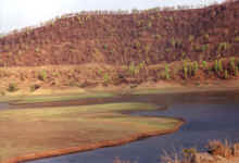
The Purna plains or the Payanghat is the main low land region.North by the Satpuda scrap and to the south by the Ajanta scrap, the Purna valley is believed to be a Graben floor developed as a result of sag faulting during the recent past. The in facing scrap is suggestive of this view. The valley floor is alluvium in filled.
BULDANA PLATEAUS
It is initially extension of the Ajanta ranges and is marked sharply by a scarp fault from the purna plains to its north. It is an undulating rolling country, the landscape, here, in contrast to the monotony of the flat purna plains is rich and varied with fertile villages in valley bottoms alternating with barren desolate hills and interspersed with steep-sided ridges and deep gullies. Plateau slopes to the south-east in general comprises the whole of chikhali and
mehkar.
GEOGRAPHICAL FEATURES
The foregoing description of the physical and natural environment helps in understanding the regional patterns within the district. Buldana is typical of the prosperous cotton framing tracts of the Tapi-Purna valley; the keynote to human life in the district is cotton framing and ginning with attendant problems in the plains. Yet regionally, there is an interesting variation in the physical environment and pattern of human economy. The district falls into three distinct physic-structural divisions well demarcated by two fault planes, running nearly west to east; in fact the transition between one regional unit and another is rather sharp and through a vary narrow elongated strip, often 2 to 4 km in width. To the north, lies a small area in the Satpudas, a hilly region; to the south lies the Buldana plateau, a rolling upland sloping gently to the south-east; in the middle, lies the alluvium in filled graben of the Purna valley or the
Payanghat.
SATPUDA REGION
Approximately, a third of the area of Jalgaon Tahsil lies in the physical unit. It is the part of the Melghat or Gavilghat hills. These hills rise to general elevation of 600 to 70 m, with occasional peaks rising to a thousand meters or more and present sheer cliff walls to the Purna plains in the south. The hills rise abruptly within a distance of less than 5 km. To their stupendous heights from the valley floor at about 270-m. their southern edge, indicative of a fault plane runs almost straight with a WSW- ENE strike. They are almost entirely composed of horizontal sheets of successive basic lava flows partly solid and aphanites and partly amygdule with inter bedded and layers.
The area of these hills within the district carries at its crest a structural flat plateau or mesa of an area of about 15 square kilometers, sloping is situated at its southern scrap edge and presents an excellent panoramic view of plains below.
CLIMATE
The climate of this district is characterized by a hot summer, well distributed rain fall during the south-west
monsoon season and generally dry weather during the rest of year. The cold season is from December to February. This is followed by the hot season from march to may. The south-west mason season is from
June to September. While October and November constitute the post monsoons
season.
TOP
|
|